Chile - 2006
- Usha Shah
- Sep 13, 2025
- 14 min read

Updated: Feb 12
Chile is a country located on the Pacific coast of South America. From Peru downwards it goes to the tip of S.America on West coast.
We had already been to SA earlier . On our first visit we went to Brazil and Argentina as those are the two countries where conference was organised. We jumped at the opportunity to go to SA.
Thinking we may never go again we included Equador as we wanted to visit Galapagos. And we also went to Peru to visit Machupichu, another big attraction.
This was our second visit to S. America. From New York we straight flew to Santiago, capital city of Chile.
For this trip I was in communication with an English speaking travel agent. At Santiago Airport we were received by a very young person who represented our travel agent. He seemed to know very little English. That was a big surprise. Our guide told that he has moved to another place. We reached Santiago well before the conference was starting, so that we can finish some of our local sightseeing.
Chile - is a long strip of narrow land along Pacific Ocean. It is divided in to North, Central, and Southern.
Northern Chile - Atacama Desert – The driest desert in the world, with the stunning Valle de la Luna (Moon Valley), El Tatio Geysers, and Salar de Atacama.
Central Chile -
Santiago the capital city is very beautiful offering great views of the Andes mountains. We wandered around the city at a few scenic locations .
Natural Attractions and Parks
Cerro San Cristóbal: A hill in the middle of the city with a giant statue of the Virgin Mary. Offers panoramic views of Santiago and the Andes. You can hike, bike, or take a funicular to the top.
Cerro Santa Lucía: A small hill and park in the city center, where Santiago was founded. It's a beautiful spot with fountains, statues, and great views.
Parque Forestal: A long, narrow park along the Mapocho River, perfect for a leisurely walk. It's also home to the Museo Nacional de Bellas Artes.
Modern Attractions
Sky Costanera: The tallest building in Latin America, offering an observation deck with 360-degree views of Santiago and the Andes.
Parque Bicentenario – A peaceful park with lagoons, flamingos, and walking paths along the Mapocho River.
Parque Metropolitano – The largest urban park in Santiago, home to Cerro San Cristóbal, Chilean National Zoo, and miles of walking trails.
Day Trip from Santiago


Valparaíso:
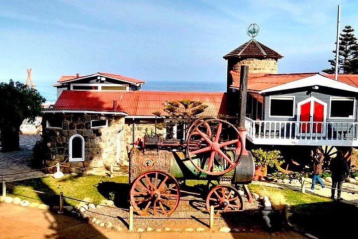
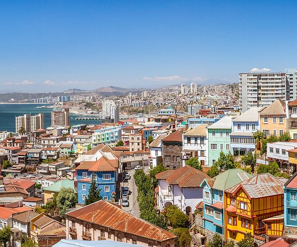
We went to Valparaíso a beautiful coastal city for a day trip. Valparaíso is a port city on Chile’s coast. It's known for its steep funiculars and colorful, clifftop homes. We first saw the city from the top. We were taken down in a Funicular - this was a unique experience. Famous place is La Sebastiana, the quirky former residence of Chilean poet Pablo Neruda, is now a museum with far-reaching Pacific views.
The city is built over about 40 layers of hills. Funiculars were used every where. One can take a boat tour of Valparaíso Bay for views of the colorful city and its port. Valparaíso hosts South America’s largest New Year’s Eve fireworks display, attracting thousands of visitors every year
Heading South – The Green Landscapes & Lakes
From here our main attraction was Mt. Osrno.
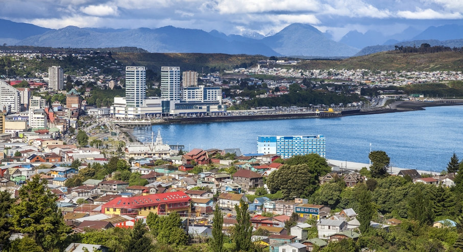
Puerto Mont German fishing village:
Puerto Montt, located in southern Chile, is a gateway to the stunning landscapes of Patagonia and the Chilean Lake District. Here are some must-see sights and activities in and around Puerto Montt: Puerto Montt and its surrounding areas offer a rich blend of cultural heritage, natural beauty, and outdoor adventure, making it a perfect destination for travelers looking to experience the essence of southern Chile. The lakeside towns of Puerto Varas and Frutillar are charming spots to visit. Views of Tenglo Island and the Calbuco Volcano. The city also serves as a starting point for exploring the Chilean Lake District and the Chiloé Archipelago, known for its unique wooden churches and rich folklore.
Cathedral of Puerto Montt:
The city's main cathedral, known for its neoclassical architecture. It is the oldest building in the city, offering a glimpse into Puerto Montt’s history.
Costanera de Puerto Montt:
A scenic waterfront area perfect for a relaxing walk, offering beautiful views of the Reloncaví Sound and the surrounding mountains.
Monumento a la Colonización Alemana:
A monument commemorating the German settlers who founded Puerto Montt, located in a small park with great views over the bay.
Nearby Attractions
Vicente Pérez Rosales National Park:
Located about an hour's drive from Puerto Montt, this park is home to the stunning Petrohué Waterfalls and the Osorno Volcano. Ideal for hiking and nature photography.
Lake Llanquihue:
One of the second largest lakes in Chile, offering spectacular views of the Osorno and Calbuco volcanoes. The lakeside towns of Puerto Varas and Frutillar are charming spots to visit.
it lies within the Llanquihue and Osorno provinces. The lake's distinctive fan-shaped form was sculpted by successive piedmont glaciers during the Quaternary glaciations, with the last glacial period referred to as the Llanquihue glaciation in Chile.This picturesque lake is renowned for its stunning views of the Osorno and Calbuco volcanoes, making it a popular destination for tourists.
The lake's pristine waters are never frozen, even in winter
Surrounding Towns and Attractions
The lake is bordered by several picturesque towns:
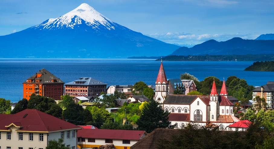
Puerto Varas: Lakeside resort:
Puerto Varas: Often referred to as the "Gateway to Patagonia," this town offers stunning views of the lake and nearby Osorno Volcano.
Known as the “City of Roses,” this town features German-influenced architecture, lovely gardens, and beautiful views of Lake Llanquihue and Osorno Volcano. The Church of the Sacred Heart of Jesus is a must-see.
A picturesque town on the shores of Lake Llanquihue, famous for its German colonial architecture, the Teatro del Lago (Lake Theatre), and the German Colonial Museum.
Frutillar: Known for its German heritage and the Teatro del Lago, a renowned concert hall that hosts the annual Semanas Musicales de Frutillar classical music festival
Day Trips and Outdoor Activities
Chiloé Island:

Temuco Market: A vibrant market where you can find traditional Mapuche crafts and products, providing insight into the region’s indigenous culture.
As we go south we encounter lush forests, lakes, volcanoes, and indigenous Mapuche culture. For our sightseeing plan we had decided to visit following destinations
Osorno Volcano
Part of Vicente Pérez Rosales National Park, Chile’s oldest national park.

Osorno Volcano is the Icon of Southern Chile
Our first destination was to see Osorno Volcano - one of Chile's most iconic and picturesque volcanoes, located in the Los Lagos Region of southern Chile. It’s part of the Andes mountain range and stands proudly between two lakes - Lake Llanquihue and Lake Todos los Santos.
It is located near the towns of Puerto Varas and Ensenada in southern Chile. We took a flight from Santiago that took us to Osorno's airport, Bajo Carlos Hott Siebert Airport (ZOS) — that's the main airport serving Osorno, in the Los Lagos Region of southern Chile. The flight Duration is Approximately 1 hour and 35 minutes. The airport is located about 5 km (3 miles) southeast of Osorno city center, so it's a short drive into town once you land. At the Airport we were met by our young guide and the driver. Next day they took us for sightseeing. Our driver requested us if we will allow him to take an additional person who did not have a car . We allowed him to do that. He promised that next day he will take us to additional places for sightseeing. We had more time and we were happy to see some more sites around the volcano. As a result he took us to see Lake Lake Llanquihue and Petrohué Waterfalls.

Rising majestically between Lake Llanquihue and Lake Todos los Santos in Chile’s Los Lagos Region, offering stunning reflections of the peak. Osorno Volcano is a nearly perfect cone-shaped stratovolcano that dominates the Patagonian skyline like a snow-capped sentinel of the Andes.
From afar, it resembles Japan’s Mount Fuji, its symmetrical silhouette mirrored in the still waters of the lakes below. The volcano’s slopes are often cloaked in white year-round, thanks to its glacial cap, contrasting beautifully with the lush green forests and deep-blue lakes that surround it. Osorno is often called “the Mount Fuji of South America” due to its graceful, snow-covered cone and perfect symmetry, just like the iconic mountain of Japan. Though Osorno hasn’t erupted since 1869, it remains an active volcano.
Highlights of Osorno Volcano:
Osorno is often called “the Mount Fuji of South America” due to its graceful, snow-covered cone and perfect symmetry, just like the iconic mountain of Japan.
Striking Symmetry: Its flawless cone shape makes it one of the most photogenic volcanoes in the world.
Snow-Capped Beauty: Visible from miles away, the snow covering its peak sparkles in sunlight, especially during winter.
Adventure Hub: Activities like skiing, hiking, and even zip-lining are available on its lower slopes.
Volcanic Landscape:It is Stratovolcano — built up by many layers of hardened lava and ash.Surrounding terrain features ancient lava flows, black sand beaches, and vibrant forested valleys.
Scenic Beauty: Its snow-capped peak and perfect cone shape resemble Mount Fuji in Japan. On a clear day, it’s visible from far across the lakes and forests.
Lake Views: The volcano rises dramatically from the shores of Lake Llanquihue, the second-largest lake in Chile.
Photogenic: It’s a favorite subject for photographers due to its symmetry, reflection on lake waters, and dramatic skies. This volcano is more than just a geological feature—it’s a symbol of the natural harmony between fire and ice, standing as a serene yet powerful presence in southern Chile.
Last Eruption: 1869 (though it's considered potentially active).
What Makes It Special?
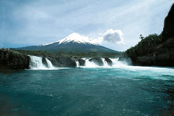
The emerald-green water flows over lava rocks formed by past eruptions of the Osorno Volcano, creating dramatic and photogenic cascades. On a clear day, you can see the Osorno Volcano looming majestically behind the falls, making for an iconic view. The water has carved smooth channels and pools in the volcanic rock, and during high water flow, the force is truly impressive.
Next day he took us to Lake Llanquihue, the second-largest lake in Chile, located in the Los Lagos Region. This picturesque lake is renowned for its stunning views of the Osorno and Calbuco volcanoes, making it a popular destination for tourists. It is the second-largest lake in Chile. It is located near Puerto Varas, Frutillar, Puerto Octay From here we get stunning vistas of Osorno and Calbuco volcanoes.
The Petrohué Waterfalls:
It is located near Puerto Varas
Chile's Vicente Pérez Rosales National Park:
This park is home to the stunning Petrohué Waterfalls and the Todos los Santos Lake is located at base of volcano. The Petrohue River over flows from this lake. waterfall is at base of Osorno Volcano , along the Petrohue River that starts at base of volcano.
It takes about an hour's drive from Puerto Montt. The Petrohué Waterfalls (Saltos del Petrohué) are a captivating natural attraction located in. These waterfalls are renowned for their vibrant turquoise waters that cascade over ancient basaltic lava formations, a result of past eruptions from the nearby Osorno Volcano. The striking color of the water is due to minerals carried from the glaciers of the Andes Mountains.
Location and Access
Situated approximately 50 kilometers from Puerto Varas, the Petrohué Waterfalls are easily accessible via Route 225-CH. Public transportation is available, with buses departing every 30 minutes, making it a convenient destination for travelers . The waterfalls are part of the scenic route between Puerto Varas and Bariloche, Argentina, and are a popular stop for tourists exploring the region.
Visitors can enjoy several walking trails and viewing platforms that provide different perspectives of the waterfalls and the Osorno Volcano. The trails are generally easy to navigate, making the site accessible to a wide range of visitors. The combination of cascading waters, volcanic rock formations, and verdant surroundings creates a mesmerizing experience for nature enthusiasts and photographers alike.
After enjoying the Los Lagos Region we went further south.
Southern most part of Chille.
Our next destination was Torres del Paine. A spectacular national park located in the Patagonia region of southern Chile, known for its dramatic mountain peaks, turquoise lakes, glaciers, and wild landscapes. The name "Torres del Paine" translates to "Towers of Paine," referring to the three iconic granite spires that dominate the skyline — Las Torres. We drove from Osorno to Puerto Montt to take a flight to Puerto Natales . We met our guide at the airport. From here he took us to Torres del Paine by car.
Here are some key highlights of Torres del Paine National Park:

Las Torres (The Towers): The park’s most iconic sight — three towering granite peaks rising dramatically from the Patagonian landscape. The park’s iconic granite peaks that rise nearly 2,500 meters. The Base of the Towers Hike (8-10 hours round trip) is the most famous trek to see them up close.
The W Trek: A world-famous multi-day trekking route that passes major landmarks like Grey Glacier, French Valley, and Las Torres.
Lago Pehoé and Lago Nordenskjöld: Beautiful lakes with striking colors due to glacial meltwater.
Southern Patagonia
Grey Glacier & Lago Grey:
Grey Glacier is a glacier in the Southern Patagonian Ice Field, just west of the Cordillera del Paine. It flows southward into the lake of the same name. Before dividing in two at its front end, the glacier is 6 kilometers wide and over 30 meters high.Take a boat tour on Lago Grey to see massive blue icebergs and the impressive Grey Glacier.
French Valley (Valle Francés):
A spectacular viewpoint with panoramic views of surrounding mountains and glaciers.
Nordenskjöld Lake & Pehoé Lake:
Beautiful turquoise lakes reflecting the towering peaks. Perfect for photography, short hikes, and boat rides.
Wildlife Watching:

Guanacos (related to llamas) roam the grasslands. Pumas can sometimes be spotted near the mountains. Andean condors soar above the cliffs.
Best Time to visit
October to April (Patagonian summer).
Back again to Puerto Natales → Boarded the ferry northbound.
Here I am diverting to describe our journey south .Icefields can be devided as Northern and Southern. Where You See the Ice Fields.
Ice field seen from the aeroplane.
Northern Patagonian Ice Field (Campo de Hielo Norte).
The Southern Patagonian Ice Field (Campo de Hielo Sur)
These Icefields together make the second-largest contiguous extrapolar ice field in the world, after Antarctica and Greenland.
Northern Patagonian Ice Field
The Northern Patagonian Ice Field becomes visible and accessible between Coyhaique and Puerto Río Tranquilo,

The Southern Patagonian Ice Field
The Carretera Austral runs from Puerto Montt (north) to Villa O'Higgins (south).
Flying vs. Driving:
If you fly from Santiago to Balmaceda (near Coyhaique) and then go southward by car/bus. You bypass the northern stretch of the Carretera Austral but reach the Ice Field area quicker.
From Balmaceda → Coyhaique → Puerto Río Tranquilo = ~6–7 hours by road.
Summary:
If you start from Santiago, you need to:
Either drive/fly to Puerto Montt, then head south, or
Fly to Balmaceda to shorten the land travel.
Exploradores Glacier
San Rafael Glacier (boat trip or flight)
Laguna San Rafael National Park
These are westward offshoots from Puerto Río Tranquilo.
If you were flying from Santiago to Puerto Montt:
It's possible (though less likely) that you saw parts of volcanic glaciers on high peaks like Volcán Osorno or Cerro Tronador, but not the massive ice fields yet.
If you were flying farther south, like from Puerto Montt to Puerto Natales:
Northern Patagonian Ice Field (Campo de Hielo Norte), and more likely, the Southern Patagonian Ice Field (Campo de Hielo Sur), the second-largest contiguous extrapolar ice field in the world, after Antarctica and Greenland.
Fly to Puerto Montt – This is the traditional starting point of the Carretera Austral.
Drive/ferry south along the Carretera Austral through:
Chaitén
Puyuhuapi
Coyhaique
Puerto Río Tranquilo
Eventually toward Villa O’Higgins (southern terminus).
The Southern Patagonian Ice Field (Campo de Hielo Sur)
The Southern Patagonian Ice Field lies along the border of Chile and Argentina, south of the Northern Ice Field—and is by far the larger and more dramatic of the two.
It's about 350 km long and home to some of the most famous glaciers in the Southern Hemisphere.
It feeds glaciers like Grey, Viedma, and Upsala. It’s only accessible by air or multi-day treks, so seeing it from the sky is a rare and beautiful privilege.
Glaciar Grey
Glaciar Viedma
Glaciar Upsala
Glaciar Perito Moreno (in Argentina but visible from certain flight paths)
These glaciers spill into stunning lakes and fjords and are often visible from airplane windows on clear days.
WE certainly saw one of the Patagonian Ice Fields, and based on your southward route and the “field of ice” appearance from above, it was most likely the Southern Patagonian Ice Field (Campo de Hielo Sur).
A vast, continuous expanse of ice stretching over mountains—more like a frozen white plateau with crevasses and texture, rather than a single glacier winding down a valley. From the plane, it would look like an endless frozen land, especially on a clear day.
Return Journey. Going back from South to North
Navimag Ferry Route Map:
This map outlines the ferry's path, highlighting key points such as Puerto Montt, Puerto Edén, and Puerto Natales. It provides a clear view of the voyage through the intricate channels and fjords of Patagonia.

Chile offers spectacular natural landscapes, and traveling by boat along its coastline from south to north is an unforgettable experience. Here’s a suggested route focusing on nature, wildlife, and scenic boat journeys:
Osorno → Puerto Montt → Puerto Natales (flight)→ Torres del Paine (by car)→ Back again to Puerto Natales → Boarded the ferry northbound.
A Journey Through the Fjords: Our Ferry Adventure in Patagonia
Traveling through Patagonia is an adventure in itself, our journey was from south to back north by ferry.
From Porto Natales in south back to Puerto Montt
Black Swans seen at Puerto Natales:

In Japan in Hokkaido we had visited a lake to see Swans.
After about an hour’s drive, from shin Sapporo, we reached Lake Utonai—a freshwater lake northeast of Tomakomai, just twenty minutes from New Chitose Airport. We went there twice, drawn by the peaceful sight of white swans gliding across the still waters. At that time I read that at some places one can see Black swans - not fully Black. Waiting for ferry at Punta Natales from a distance we did see Black swans.
A Journey Through the Fjords: Our Ferry Adventure in Patagonia.
We chose to sail through the labyrinth of fjords, channels, and open waters that make up Chile's southern coast. This decision led us to one of the most unique and unforgettable voyages of our travels.
Traveling through Patagonia is an adventure in itself, but our journey back north by ferry from Puerto Montt was an experience unlike any other. Time was limited, and instead of retracing our steps by road, we chose to sail through the labyrinth of fjords, channels, and open waters that make up Chile's southern coast. This decision led us to one of the most unique and unforgettable voyages of our travels.
We had a cabin that accommodates 4 people. So we had a gentleman from Scandinavia who was younger than us.

The ferry was no ordinary passenger ship. It was a lifeline connecting the remote communities of Patagonia, carrying not just people but an astonishing variety of cargo. As we boarded, we found ourselves among fellow travellers, mostly younger and far more adventurous than us, eager to embrace the rugged beauty of the journey. But what caught our attention the most were the animals. Dozens of horses stood in their designated area, shifting restlessly as the ferry gently swayed. There were also parcels of all shapes and sizes, each bound for a destination that roadways could not easily reach.
The first part of the journey was peaceful. We passed through serene waters, flanked by towering cliffs and dense forests that seemed untouched by time. Occasionally, we spotted small fishing villages clinging to the edges of the land, their colourful houses adding a touch of warmth to the otherwise stark, windswept landscape.
But Patagonia is never predictable. As we entered a narrow channel, the sea turned rough. The once gentle rocking of the ferry became a battle against the waves, and the vessel groaned with each surge. The animals, sensing the change, grew restless. Some of the younger travelers reveled in the excitement, bracing themselves against the wind and rain that lashed the deck. For us, it was a moment of reflection—an intimate encounter with the raw power of nature.
Then, something extraordinary happened. Amidst the turbulence, one of the horses went into labor. The ferry crew and passengers quickly gathered to assist, their efforts guided by an experienced traveler who had seen such events before. Despite the harsh conditions, a new life entered the world, right there in the middle of the Patagonian sea. The sight of the newborn foal struggling to stand on wobbly legs amidst the chaos of the storm left an indelible mark on all of us. It was a moment of pure wonder—a reminder that life continues even in the most unexpected places.
As the seas calmed and we approached our destination, the sense of camaraderie among passengers grew. We had shared an adventure that none of us would forget, each carrying away a different memory of the journey. For us, it was not just about reaching the next port—it was about experiencing Patagonia in its most authentic and untamed form.
Looking back, I realise that this ferry ride was more than just a means of transport; it was a microcosm of life in Patagonia. A place where people, animals, and nature coexist in a delicate balance, where unpredictability is the only certainty, and where every journey holds the promise of a story worth telling.
Traveling through Patagonia is an adventure in itself, but our journey back north by ferry from Puerto Montt was an experience unlike any other. Time was limited, and instead of retracing our steps by road, we chose to sail through the labyrinth of fjords, channels, and open waters that make up Chile's southern coast. This decision led us to one of the most unique and unforgettable voyages of our travels.
When we came out we were happy to see our guide and driver. From Puerto mont we were planning to go to Bariloche.
After reaching Puerto mont our plan was to travel by boat to cross over through lakes and enter Argentina.
Petrohue - Peulla by ferry - 2 hours
Peulla → Puerto Frías (by bus)
Small bus through the Andes, crossing the border into Argentina.
Puerto Frías → Puerto Blest (by ferry)
Cross Lake Frías (short ferry).
Puerto Blest → Puerto Pañuelo (by ferry)
Larger boat on Nahuel Huapi Lake, finishing near Bariloche.
Puerto Pañuelo → Bariloche (by bus)


Comments